


 The first Africa Geospatial Data and Internet Conference (AGDIC) concluded successfully in Accra on 24 October, bringing together more than 1200 participants from all over the world. The conference firmly emphasized the need for geospatial data and Internet adoption as key to development programs solving Africa’s complex problems. The conference also facilitated much needed exchanges between various data stakeholders.
Under the theme “Shaping Africa’s digital future,” the three-day conference hosted a thought leadership discussion, plenary sessions on Internet governance, geospatial data and Next Frontier technologies applied to sectors such as agriculture, mining, urban planning, water & sanitation, natural resources. Training was also carried out by NASA/SERVIR representatives on machine learning, IOT and AI, cloud computing. Several sessions were held on geospatial ICTs and related technologies including LiDAR, surveying, mapping, drones and more. A two-day hackathon on satellite data for agriculture and related applications was organized and sponsored by the Agence Francaise De development (AFD).
Successful technology adoption for societal benefits calls for inclusiveness of diverse stakeholders; understanding this, the conference hosted dedicated sessions on two very important groups – the Youth and Women. These respective forums brought out important points on these groups’ engagement with technology.
The conference also included exhibitors that showcased latest geospatial technology applications relevant to different sectors and industries.
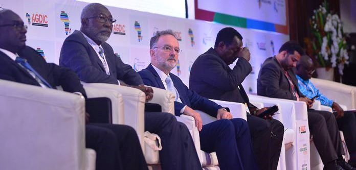
The Director General of the Ghana’s National Development Planning Commission (NDPC), Dr Kodjo Essiem Mensah-Abrampa gave the welcome address and called on African governments to invest in geospatial technology as it is a key driver to our continent s future. Keynote speakers at the opening ceremony were the Regional Representative of the United Nations FAO, Dr. Abebe Haile-Gabriel; the Minister of Lands and Natural Resources, Hon Kwaku Asomah Kyeremeh, the United States Ambassador to Ghana, Stephanie S. Sullivan; USAID West Africa Regional Mission Director, Daniel Moore; Project Manager SERVIR Head - Global Earth Monitoring Network, NASA, Daniel Irwin; Chairman of Ghana Dot Com Prof. Nii Quaynor; Executive Director of GODAN, Andre Laperriere, and the Vice President of Geospatial Media and Communications, Prashant Joshi.
Ministerial Conference
At the Ministerial conference held at the conference, nine (9) Africa Countries representatives of Ministers agree to the Accra Declaration on Open data on Agriculture, Nutrition. Countries who agreed to the accord are expected to work with their respective governments to implement the declaration.
AGDIC 2019 was Co-organized by Africa Open Data and Internet Research Foundation, SERVIR West Africa and Global Open Data for Agriculture and Nutrition (GODAN), Geospatial Media and Communications, in partnership with the National Development Planning Commission (NDPC) Ghana, Ghana Statistical Service (GSS), McGill University Canada, Agence Francaise De development France, Ministry of Lands and Natural Resources Ghana, CTA Netherlands, Woolpert USA, Rocketmine Ghana, Sambus Geospatial Limited, Ghana, and ICANN.
The next Africa Geospatial Data and Internet Conference, AGDIC 2020, is billed to take place in October 2020, in a country, which will be announced soon.
Meanwhile, the global momentum on geospatial and Internet technologies will continue at the Geospatial World Forum 2020, being organized April 7-9 in Amsterdam, The Netherlands, by Geospatial Media & Communications. The Geospatial World Forum is an annual gathering of geospatial professionals and leaders from 70+ countries under one roof, showcasing the latest in technology, trends and applications in the industry. The conference will especially witness participation from fast growing economies from Asia, Africa, Latin America, using geospatial leverage to support their development plans. Conference details can be referred at www.geospatialworldforum.org
About African Open Data and Internet Research Foundation
The African Open Data and Internet Research Foundation is an African based organization that champions open data, internet policies and capacity building, in support of innovative ideas, projects and programs across the Africa. More information can be viewed at www.afrigeocon.org / https://aodirf.org/;
Contact:
Wisdom Donkor; This email address is being protected from spambots. You need JavaScript enabled to view it.
Kwaku Antwi; This email address is being protected from spambots. You need JavaScript enabled to view it.
Odelia Ntiamoah; This email address is being protected from spambots. You need JavaScript enabled to view it.